Click on the relevant box below to jump to that opportunity.
Characterization of limestone deposits
Opportunities for ground calcium carbonate (GCC)
Production of precipitated calcium carbonate (PCC)
Opportunities for lime
Limestone in premixes
Limestone for 3D concrete printing
Characterization of limestone deposits
Background
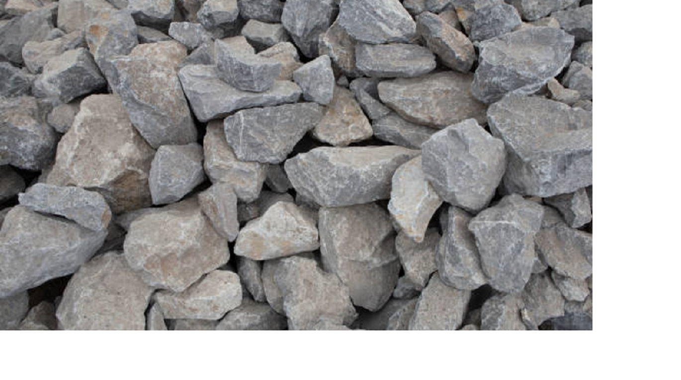
Oman has a strong limestone industry but discussions during local scouting show that most Omani limestone is used in low-value applications such as aggregate. As limestone probably has the largest number of commercial applications of all the industrial minerals, this suggests that opportunities are being missed, and interviewees emphasized that Oman has high-purity limestone deposits that could be used for higher value applications.
Information on the characteristics of Omani limestone deposits is incomplete and scattered. Making the most of limestone deposits requires that Oman invests in characterization of its limestone resources in appropriate detail, and ensures the information is accessible to potential investors. Such resource assessment is conducted through reconnaissance surveying, which refers to a government-funded strategic resource assessment programme.
The British Geological Survey (BGS) has developed and published descriptions of the process for reconnaissance surveys of limestone, based on techniques tested in many countries including Thailand, Zambia, and the Middle East (especially the United Arab Emirates). This section outlines a recommended approach for reconnaissance surveys of Omani limestone, based on information from BGS publications and on primary research1,2,3.
Limestone properties for higher value applications
The BGS has published a summary of the properties of limestone required for a range of commercial applications (Table 8‑1). Reconnaissance surveys aim to assess these characteristics to indicate the possible end-use of a resource.
Table 8‑1. Properties of limestone

Reconnaissance process
Overview
Figure 8‑1 summarizes the overall process of reconnaissance and the following sections provide further detail.
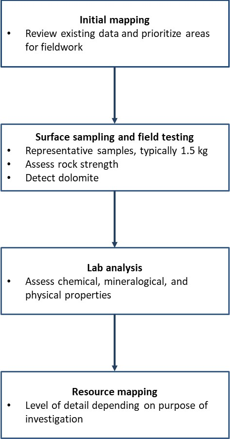
Figure 8‑1. Overview of reconnaissance process for limestone
Initial mapping
The first stage of a reconnaissance survey is a review of the existing available geological information in maps and reports. All existing information should be collated and used to categorize limestone resources into priorities for survey field work. The highest priority is given to formations with thick, uniform sequences that consist largely of limestone. The lowest priority is given to formations that do not contain significant amounts of limestone; have large amounts of dolomite, chert, and other non-limestone mineral impurities; have thin, inconsistent sequences; and are interbedded with non-limestone rock types such as sandstone, siltstone, and mudstone.
A geographical information system (GIS) map is created to incorporate all available information on the geology including limestone resources (ranked as potentially high, medium, or low purity), topography, satellite imagery, and infrastructure.
Surface sampling and field testing
The next stage is reconnaissance survey field work, aiming to collect samples that are representative of all the limestone formations identified over a wide geographical area. The location of each sample is recorded using a handheld GPS device. Limestone samples, typically 1.5 kg, are taken from rock outcrops, avoiding overly weathered, fractured, and mineralised surfaces. For reconnaissance surveys, surface samples are taken. Later, if more detailed resource assessments are needed, drilling is carried out and samples are taken from both cored boreholes and rock sections, creating a detailed resource survey that covers variations in the local rock.
Field testing is used to assess rock strength (especially important when aiming for appraisal of aggregate quality) and to identify and quantify dolomite. Two techniques are used to assess rock strength:
-
The Schmidt hammer: a lightweight and portable hammer that measures the distance of rebound of a controlled impact on a rock surface to give a relative measure of surface hardness or strength, to predict aggregate strength.
-
The point load test: Assesses crushing strength of specimens in a customized apparatus and provides an indicator of tensile rock strength.
Various techniques are used to detect dolomite:
-
Field observations: Surface texture, colour, hardness, smell, topography, and presence/absence of fossils can indicate presence of dolomite but need to be supplemented by other approaches.
-
Acid reaction test: Reaction with chemical acid can distinguish limestone from dolomite but this technique is not reliable in high temperature climates (because dolomite reacts more vigorously at increased temperatures) so is unlikely to be applicable in Oman.
-
Chemical staining: Various chemical stains distinguish calcite (in limestone) from dolomite through colour, but accuracy of these approaches are limited.
-
Density determination: Calcite density is 2.71 g/cm3 and dolomite density is 2.85 g/cm3; can be useful but can be difficult to achieve sufficient sensitivity to provide accurate assessment of mixtures, and other impurities (e.g. quartz, pyrite) can complicate the measurements.
-
Infra-red measurements: A portable infra-red analyser can provide a useful and non-destructive first step to assessing dolomite during field appraisals.
Other geophysical techniques such as electromagnetic, resistivity, and ground radar surveys are also used in the field to determine the distribution of poor-quality rock or the presence of caverns in areas designated for quarry development. However, they are mainly used for detailed site investigations rather than for reconnaissance surveys.
Lab analysis
Detailed laboratory studies in addition to field geological studies and basic field testing are needed to investigate the mineralogical, chemical, and physical properties of rocks. The choice of tests is informed by the needs of industry so depends on the intended end use.
Mineralogical approaches
X-ray diffraction studies are used to determine the presence of calcite and dolomite together with common impurities such as quartz, feldspars, clay minerals, pyrite, and iron oxides. Thermogravimetric analysis is carried out to provide more sensitive determination of carbonate mineral content. Petrographic studies, which are the study of rocks in thin sections, are also conducted, using a binocular microscope. They provide information on lithology (physical characteristics of rock), grain types, colour variations, texture, porosity, sedimentary and organic structures, carbonate and non-carbonate mineralogy.
Chemical approaches
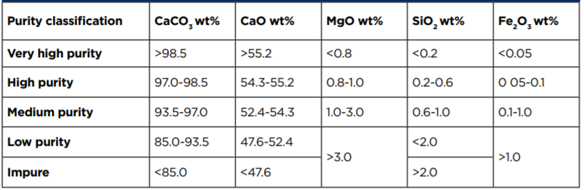
Chemical purity is usually determined by X-ray fluorescence analysis and the data are used to classify limestone according to primarily to the calcium carbonate content (Table 8‑2).
Table 8‑2. Classification of limestone according to levels of calcium carbonate and other key minerals.
Physical approaches
Commercial data sheets provide information on many properties such as moisture, bulk density,surface area, etc. The BGS recommends that chemical rather than physical properties are included in reconnaissance surveys because most physical properties vary depending on the milling process. An exception is brightness/whiteness, which the BGS does include in reconnaissance surveys because of its commercial importance. Brightness is measured with a reflectance spectrophotometer, with the percentage of reflectance directly proportional to the whiteness of the sample. Brightness values greater than 80% are the minimum for high purity limestone samples.
Resource mapping
The final stage in a reconnaissance survey is to compile a resource map. A scale of 1:100,000 or even 1:200,000 may be used for reconnaissance surveys of large areas, but a scale of 1:50,000 is usually recommended, and interviewees during local scouting emphasized that Oman needs to carry out mapping at this scale. Reconnaissance maps illustrate the general variation in resource quality and may also show topographic information, underlying geology, and sample points, as well as administrative and legislative boundaries, extraction licences, and transportation routes.
Information from reconnaissance surveys is used by explorers to assess the potential of an area.Companies are likely to need to carry out more detailed resource assessments on specific areas, which include mapping to a higher scale, up to 1:10,000. The most detailed assessments of resources or reserves identify and quantify the resource or reserve and all constraints (physical, environmental,legal, administrative, economic, etc.) on development.
Next steps
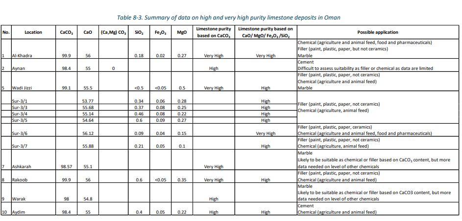
The Omani government has collected some data on purity of limestone deposits. Analysis of these data and comparison with the criteria in Table 8-1 indicates that there are 13 deposits of high or very high purity limestone.
Table 8-3 summarises the available data and suggests applications that may be suitable for these deposits, based on the criteria provided in Table 8-1. The government data includes other deposits but these are of medium purity or lower. Further details are provided in an Excel sheet accompanying this report (Chemical Analysis of Omani Limestone).
Overall, the data available to the Omani government support comments made by interviewees that Oman has significant potential to produce higher value limestone products. Investing in further characterization is likely to be worthwhile and is an essential step in ensuring that Oman gains added value from its limestone resources.
LIST OF OPPORTUNITIES
All opportunities are listed below in their respective clusters. Click on each opportunity to find out more.